Welcome to the RAVE project portal.
Introduction
Operators of critical rail infrastructure face continuous challenges in monitoring their networks for ongoing maintenance, and preventing potentially catastrophic accidents. In recent years, Earth Observation technology has greatly enhanced our ability to undertake remote, large-area monitoring, yet many challenges remain unresolved. This project will assess the synergistic utility of the upcoming CHIME (hyperspectral) and ROSE-L (L-band SAR) Copernicus Expansion Missions for a range of high-accuracy railside monitoring applications, including the detection of changing lineside land-cover (tree species, tree height and land use) and risk (tree disease, tree windthrow and flooding). Working in collaboration with UK-based rail operator Network Rail and their French counterpart, the Société Nationale des Chemins de fer Français (SNFC Réseau), Airbus will develop a novel, multi-sensor monitoring system capable of providing European rail operators with actionable information to enhance lineside management activities. Ahead of their launch, this monitoring system will use emulated CHIME and ROSE-L datasets, which will be obtained via the modification of existing hyperspectral and L-band SAR imagery, respectively, to match the imaging characteristics associated with these missions.
This project is carried out under a programme of, and funded by, the European Space Agency.
 Copernicus Sentinel Expansion Missions. Source: ESA (https://www.esa.int/ESA_Multimedia/Images/2022/01/Copernicus_Sentinel_Expansion_missions)
Project Objectives:
- To develop a novel, multi-sensor monitoring system to provide European rail operators with actionable information and enhance lineside management activities.
- To demonstrate the utility of synergistic CHIME and ROSE-L observations for systematic, high-accuracy lineside monitoring.
Project Applications:
Application I: Rail-adjacent Land Cover
This application will use emulated CHIME and ROSE-L imagery to recover detailed information on lineside Land use, Tree Species and Tree Height
Application IIa: Rail-adjacent Hazards (Tree Disease and Disturbance)
This application will exploit the hyperspectral imaging capabilities of CHIME, and enhanced canopy penetration potential of ROSE-L, to monitor Tree Disease and Windthrow in unprecedented detail.
Application IIb: Rail-adjacent Hazards (Flooding)
This application will test the utility of ROSE-L (L-band SAR) for monitoring Flooded Areas, including inundated vegetation regions where C-band SAR (e.g. Sentinel-1) normally fails.
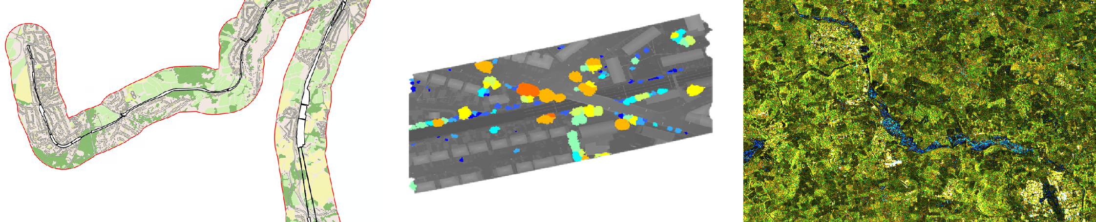 Left: Example of rail-adjacent land cover derived from satellite imagery produced within the ESA-funded LUCI project. Centre: Tree-risk based on LiDAR data. Within RAVE, the potential of ROSE-L derived tree height will be explored for the purpose of hazard mapping. Lidar image courtesy of Network Rail, 2022. Right: Sentinel-1A dual-pol image composite dated 18th Nov 2021, showing flooding (blue) in Aberdeenshire, Scotland. Image credit: contains modified Copernicus Sentinel data (2017), processed by Airbus Defence & Space UK Ltd. Courtesy of Airbus Defence and Space Ltd.
